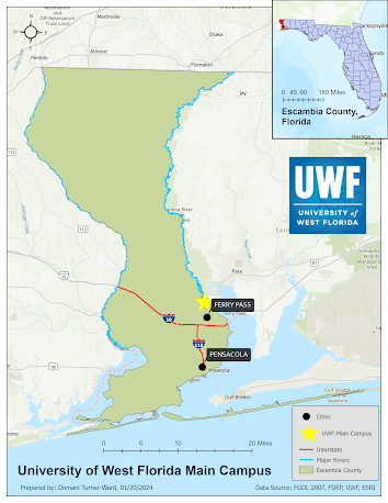
Georeferencing

This map depicts the main campus of the University of West Florida, including buildings, roads, and an eagle nest.
In this project, I learned how to georeference. I was given road and building layers that were already properly georeferenced. Then, I added two aerial photographs and added control points matching the properly projected features with aspects of the photographs. I made an effort to keep my total RMS for each raster below 15. I also learned how to edit and add polygons; I added a building and road based on the aerial photographs. In addition, I created an inset that includes a multiple ring buffer demonstrating sensitive area around an eagle nest.
Comments
Post a Comment