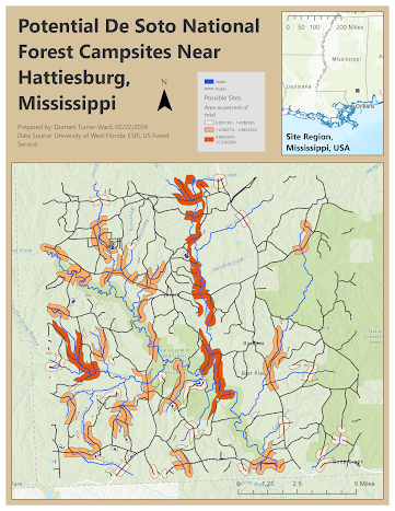
Cartography: UWF Main Campus Location Map

This map shows the location of the University of West Florida Main Campus, including an inset map demonstrating the location of Escambia County within Florida. It also includes major highways, rivers, and cities within Escambia County.
In this module, I learned about and experienced the cartographic process. I learned what essential elements I must include in all my maps from here on, as well as how to include them. Principles of design and layout creation were major learning outcomes. I also gained experience finding and exploring metadata.
First, I learned to view and explore metadata within ArcGIS, and using these techniques, I noted important information about the sources and forms of the data used in this project. Second, I created a basic map layout, starting with an inset of the state of Florida, followed by a larger spread zoomed into Escambia County. Third, I edited the data representation on the larger map by clipping major rivers and major highways using the Escambia County boundary data, making it so these layers were only visible in the area representing Escambia County. Fourth, I used definition queries to pare down data in an attributes data to show only major Escambia County cities. Fifth, I edited symbology so that appropriate colors were used to represent features throughout the map. Sixth, I used the Label tool to add labels to the cities and highways. Finally, I added essential map elements; for Title, Cartographer Name, and Data Source, I used the insert rectangular text tool; for the legend, north arrow, and scale bar, I used the appropriate tools.
Comments
Post a Comment