ArcGIS Field Map Mobile and Sharing Maps
In this project, I explored data collection and communication using ArcGIS Pro and Field Map Mobile, then practiced sharing the resulting map in multiple formats.
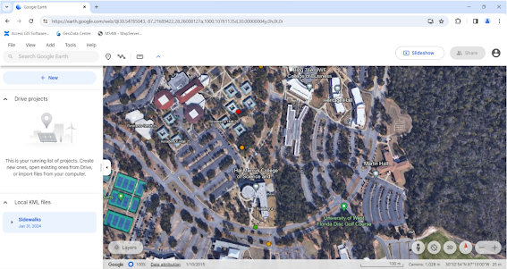
First, I used ArcGIS Pro to create a map with appropriate domains: Excellent, Fair, and Poor. Then, I created a new empty Feature Class, with fields for Condition, Notes, and a photo, leaving the projection as Web Mercator. I edited the symbology so that Excellent condition is represented by a green dot, Fair condition by an orange dot, and Poor condition by a red dot. Then, I connected to the UWF Organization to share the feature class as a web layer. From there, I created a web map from ArcGIS Online so that I could add data from Field Maps. Then, I downloaded Field Maps to my phone and collected data from an area of the UWF campus! I chose to highlight and investigate the state of sidewalks on the university campus. This is a very important issue, as sidewalks in poor condition are especially dangerous for students with disabilities; several semesters ago, a poorly maintained UWF sidewalk resulted in an emergency hospitalization of a student. I collected five data points of areas of sidewalk in various conditions, primarily in the area near and between the engineering building and Pace Library. Once I completed this step, I viewed the uploaded data in ArcGIS Online and ArcGIS Pro. Finally, I prepared sharing of my map as a Web Map, a Google Earth File, and an Esri Map Package.
Web Map Link: https://pns.maps.arcgis.com/apps/mapviewer/index.html?webmap=53cd99f55aaf489e97946d0ec9e15c55
Map Package Link: https://pns.maps.arcgis.com/home/item.html?id=6417c34097514751888aba3b34b99291


Comments
Post a Comment